Syros: walking back in time

Last Friday we set off on a walk so it ended up creating its own nickname “extremehikingfridays” which obviously lends itself to some funny hashtags! At first didn’t mean for the day to be completely absorbed by a hike, but as we were enjoying exploring so much we ended up doing a full loop back to Kini, around 20k in total. Extreme-hiking lived up to its name!

We set off on the first bus from Kini to Ermoupolis at 9am, with a packed lunch, fruit and snacks and plenty of water to keep us hydrated. The route chosen would take us North out of the town, passing tiny hamlets of Richopo, crossing into Ferekidh’s Cave, up to the original settlement of Kastri and then onto the excavation site of Chalandriani. This combined a few of the existing trails mapped as 1, 2 and 3 which we thought gave us plenty of options for finishing it up with either a taxi or walk back to Ermoupoli.

The weather was warm and breezy, so not too hot for walking. But the first section was the ascent through Vrodado and the steps nearly defeated us!

20170827_114423

This leads up to Anastasi which is known as the Church of the Resurrection of the Savior. This blue domed Orthodox church sits astride the hill, opposite the hill top of Ano Syros where Agios Georgios the Catholic Church holds court. Anastasi is dedicated to “Resurrection of the nation”. Built in 1874 by the local architect Dimitris Eleftheriadis, it is very impressive with a mix of Byzantine and neoclassical elements. Once past the 200 step climb we set of walking out of the town through an area called Dhili. Here the houses are a mix of very old and newer constructions, and as you leave the confines of the urban area they start to have more land for agricultural purposes. Once we reached a Panacrandos Church, this is where the path of trail 1 started – the path is well marked and views here are spectacular.

20170818_104237

https://www.flickr.com/photos/144180115@N07/36027032703/in/dateposted-public/

Outwards over the Aegean to Tinos and Andros, taking in Cape Armonos and Agios Demetrios which is the byzantine church looking out to sea and spectacular if you get to pass it on a ferry.  After a while on this barren stone path, we came across a tiny hamlet of Richopo where there are signs to Ferekidh’s Cave (or Pherecydes of Syros as he is also known). A philosopher known as one of the Seven Sages of Ancient Greece, his work contemplated the importance of time (chronos) by using a heliotrope (sun-dial)  village of San Michalis (yep where they make Syro’s famous cheese).  but there is a bust of him in Ano Syros as well. His philosophical musings discussed metamorphosis and the underworld, as well as teaching Phythagras.

https://www.flickr.com/photos/144180115@N07/36439737560/in/dateposted-public/

Pherecydes was a complex character and very little of his written work remains – Scholars disagree on his work so this could be why signs point to his cave, yet the cave doesn’t receive historical site protection. This possibly goes some way to explain why the powers that be decided to build the municipal dump and recycling-centre less than a mile downhill from it! Which has sadly resulted in a million plastic bags are carried away on the wind from the dump and end up littering the amazing path around the cave – this was just such mess and made me pretty angry.

20170818_112026

You get plastic bags with every single purchase here. It would make a huge difference if they’re use was reduced and the authorities did more to protect the rubbish from blowing out of the site and ruining the island. Rant over!

You’ll see from the pics, it is an amazing cave. A real place of contemplation and solitude.

20170818_113726

IMG-20170818-WA0002

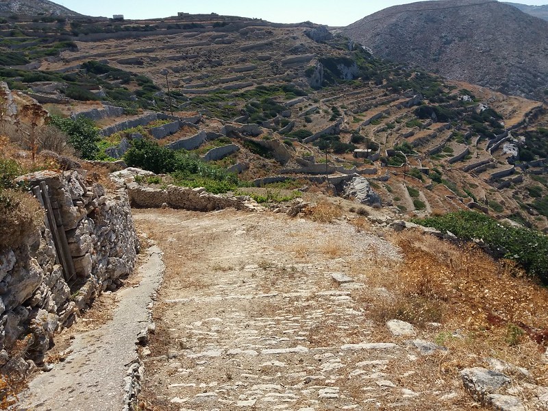
From here we scaled inland to Plati Vouni, which is a rural settlement of themonia (houses) closely built together – many households still work on the land, keeping goats and chickens, bring water up from the wells and natural springs. We even spotted a few circular threshing floors as well, although at this time of year all the hay and wheat had been collected. Apart from electricity cables this area would have changed very little in the past 50 years, being very similar to Folegandros and other Cycladic rural villages we have walked through.

20170818_122754

Passing down through a valley we headed out to coast again on route 3, losing our way slightly as we were following this immensely valuable description of the walk. Reaching a lonely house, then the trail leads down and out to the headland to reach the remote beach of Ghilsoura. Even though remote, without a road to it or electricity cables, the house was occupied by a Greek family enjoying a drink on their terrace. We misjudged and took the turn too soon – luckily the family realised what we had done as we tromped through their land, and started waving and pointing us towards the right path! We exchanged pleasantries and thanks. If it wasn’t for their intervention, I am not sure where we would have ended up.

20170818_130433

20170818_131802

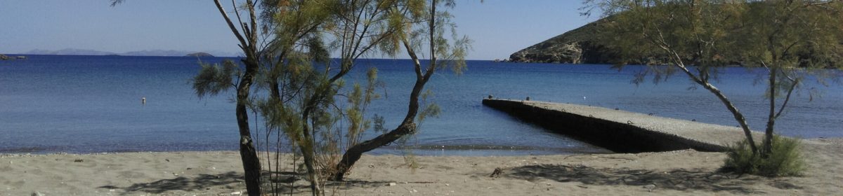
The beach at Ghilsoura is magnificent and remote, with pristine pebbles lining the shore – we took a dip here and enjoyed our picnic. This would have been one of the two beaches invaders and pirates landed at when the only settlement of Syros was at the Kastri. We looked around at the back of beach where the trail was meant to rise up to the Kastri, but the path is almost completely hidden! It doesn’t make itself known until you are right infront of it and see the red arrows marking the path. The Kastri rises from the top of the summit making it the perfect place to spot any threats and by time any invader reached the top, they’d be tired!.

20170818_141646

Dating back to the Early Cycladic period the Kastri would have been not only a fortress to protect the islanders, but also a village where the daily ritual of life went on. There have been numerous excavations over the years including the discovery of the Acropolis area at the top of the site and a graveyard with about 600 tombs. Some of the ceramic vases, stone and metalwork fragments are held by the Syros Archaeological Museum and reveal it was a sophisticated society.

https://www.flickr.com/photos/144180115@N07/36439749070/in/dateposted-public/

The climb to the top reveals its charms and practicality – no pirate invader could make it to the top without being seen! The views from up high are its main vantage point – out to sea and inland across the island. To get a real explanation of the Kastri’s scale I found a good photo here . When you are exploring it you don’t get the full sense of its scale so was good to see that aerial image beforehand and wander round accordingly.

20170818_142208

Here we came across 4 fellow walkers which is a rarity on our travels. These Greeks asked us where we had walked from and were surprised to hear we walked all the way from the town (rightly so as we’d already done 8k!) They had parked their car at Chalandriani and walked over, which is a steep 30 minute which does make the site accessible for even non-walkers. But I found walking there past the smaller hamlets first gives you a better sense of the variety of landscapes on this compact island.

After this we scaled uphill to Chalandriani which is also a small settlement and site of a large excavation. A few houses remain occupied here and terraced land dominates the view.

20170818_154523

The excavations in Chalandriani started in the late 19th Century by archaeologist Christos Tsountas  and the findings from the village are considered one of the most important in Cyclades. Figures and pottery from this site are displayed across the world on loan from their home in the National Museum in Athens. I even managed to see some pieces from Chalandriani in the Ashmolean Museum on my last visit to Oxford. So it was great to see the site they came from – although there isn’t much to actually see here.

From this road junction where the trail 3 ended, we made the epic decision to walk back to Ermoupoli, but heading on an alternative route back that passed the settlements of Kiperousa, Senero and Finikia. Although this cut through on the road this is a stretch of the island that is fairly quiet especially mid-afternoon.

20170818_160909

Once you reach Finikia, this is a few old abandoned houses and newer farms which would have been in a valley, possibly with a Spring to supply irrigation. It has the tell tale signs of a seam of lush green trees growing through the middle of the valley. It was blissfully quiet and at the same time has a ghostliness quality to it, as you walk past you can imagine life in the abandoned 19th Century dwellings and mules using the paths marked by dry stone walls. All of the paths which wind up and down would have carried goods and livestock to the markets of Ano Syros.

20170818_165914

20170818_164832

As the road corners towards Ano Syros this area is really interesting as it still has the remains of windmills. One has been kept intact and sits proudly overlooking the valley. But its doors are locked and marked by a sign saying it was restored by the Municipality. We took the steep path up to the peak of the hill where the remains of three windmills stand and then on to Alithini.

https://www.flickr.com/photos/144180115@N07/36836057605/in/dateposted-public/

The views here are breathtaking – from it you get a sense of all the histories of the island merging into one modern personality. From the medieval settlement, growing and expanding through the 18th Century in it’s industrialist heritage. Ermoupoli stretches out as a meeting place of both its the rural and urban populations, defined by many people who came as immigrants, changing the islands fortunes, religion, cuisine and culture.

20170818_175642

In Alithini, we found a path marked trail 10 which would take us up over the final hill, past the out of action wind turbine and down into Kini. This path is one of the sparse remains of the original path network that even up to the 1960s workers from Kini would have used daily. It has two options; Alithini to Kini or heading up to Aghia Varvara and then turning at Piskipio and down into the shipyards and factories of Ermoupoli – a route of 8k each way. Imagine that as a daily commute to work!

During the Italian occuoation of Syros in the Second World War, as vehicles were a still a rarity on the island, Italian soldiers would have used the old path network to solicit food from farmers and transport goods by mule. As you walk these routes which connect villages and churches on worn cobbles and marbled stones, sometimes with carved steps and bare earth, it impossible not to imagine the lives of those Syrians who walked them everyday.

By the time the sun was low in the sky we reached the bay of Kini. There was only one option, taking our aching legs and heading straight for a rewarding beer !

#extremehikingfridays watch this space for more adventures!


Folegandros – trip report

2017-07-14_03-40-04

Arriving on the ever-reliable Aqua Spirit from Syros into the port at Karavostasis (which I think literally translates as Boat place) is a little underwhelming, one can’t really believe this is it…

2017-07-10_09-58-01

Just 2 rows of old and newer buildings, a small bus shelter and the port police station. Then your eyes scan leftwards and see a tiny beach, all white pebbles and aqua blue sea. No sunloungers in sight, just a few tanned bodies and children jumping in the sea. Bliss!

2017-07-10_10-02-10

We had arranged to stay in the Chora, which is the main town 3km from the port. On an island that is 32 square kilometres and only has three settlements, visitors to the island are clearly wowed by how tiny and barren the landscape feels. We took the trusty island bus up to the Chora,  1.80E a journey and runs every hour or so in peak season, you can see how this is a perfect island to explore on public transport and by foot. Despite this, there numerous mopeds and cars hire places around should you want to, but I did hear that there is still only 1 or 2 taxi’s on the island. It seemed that most hotels and apartments run their own little shuttles picking people up at the port and back to the Chora or the second inland village, Ano Meria.

https://www.flickr.com/photos/144180115@N07/35791663446/in/dateposted-public/

I can’t really claim this island is off the beaten track anymore – that might have been truer 10 or 15 years ago, just on the fringe of discovery. But now it’s a bustling place that is evidenced by several new build all-white-boutique-hotels (I have been an observer of the personality-free phenomena in Greece for a few years now – it starts off all white washed, chrome fittings and bleached wood peppered with Instagram-style marketing and tanned bodies). Quite frankly I think it may be a regrettable trend that says nothing of the true eclectic personality of Greece. Blame the Mykono-isation of tourism, ‘build it posh and they will pay’ from Marbella to Amalfi these styled hotels are everywhere. I hope that most travellers to Greece seek something more laidback, a place that tells of history, the land and most importantly its people. Folegandros is a beautiful island, it’s streets are full of colour that juxtaposes the light and shadow, the aquamarine sea, and white pebbles, blue shutters, dark wood and terracotta. You see this on the cobbled streets of the Chora.

https://www.flickr.com/photos/144180115@N07/35785039941/in/dateposted-public/

2017-07-14_03-41-21

Once the bus had dropped us off we easily found the Anthia Hotel, over the road from the local government building and bus station. We were welcomed into a simple but very clean double room with a ground floor terrace. We were lucky to book a room in advance as we only found this 2 weeks ago, and struggled to find anything for less than 80E a night. The Anthia is a family run place, close to the entrance to the Castro and one of several recently built smaller hotels near the entrance to Pounta Square. Although no stunning views to speak of, I was placated by having plenty of bougainvillea and terracotta pots over-flowing with greenery on the hotels terraces. That is one of the thing that struck me about the island was the sheer dry barrenness of the rocky landscape. The Chora sits 200 metres above the sea perched  in its whitewashed splendour and domed churches, yet below are terraces and miles upon miles of drystone walls that criss-cross boundaries across the horizon, spiraling downwards into the turquise Aegean sea.

2017-07-14_04-01-49

It is almost unfathomable how this land was once cultivated with terraced vineyards, olives and arable land, not to mention the time it must have taken to dig out terraces, and build all the dry stone walls and stone paths that still remain connecting the islands beaches, churches and farming hamlets. Like it’s neighbour Sikinos there is a very raw beauty to this place that hasn’t been changed too much yet by tourism and I hope it stays that way.

https://www.flickr.com/photos/144180115@N07/35443844120/in/dateposted-public/

Folegandros appealed to us because of the hiking and the opportunity to explore the villages on the island, Chora and Ano Meria do not disappoint. Chora has a wonderful part of the village with the original Castro (Castle) settlement with its little rows of terraced 2 up 2 down houses – some of which are restored as little houses and some lie abandoned, but this gives a nice mix of life, colours and flowers. You can still see village life going on as it has done for centuries. Just wandering around the village in late afternoon or early morning is a wonderful quiet experience when the shops are closed and just a few people sit in the cafes and taverna’s in the main squares drinking coffee and playing tavli.

2017-07-14_03-50-45

Also like many places in the Cyclades the sunsets are something special and many people walk up to the Panagia church, up an easy 20 minute winding path at the highest point of the village to enjoy the view. After this nightly phenomenon the squares come alive and people jostle for the best table at the bustling taverna’s. It is as if hundreds of people descend on the village from nowhere! But its good to see tourists in such droves, we noticed mostly French, Scandinavians and Italians were there in July.

2017-07-14_03-40-56

The food we enjoyed was matsata, a local pasta of thick deliciously soft ribbons usually served with sweet tomato stew usually with goat, rabbit or rooster. (I enjoyed goat matsata thoroughly!) Most taverna’s brought over caper dip with bread; a delicious salty spread, perfect with olives and cheese.  The islanders are also famous for a soft cheese known as Souroto, which is similar to other local cheeses I had tried in Naxos and Sikinos, each islands gets its own unique version. Luckily the island’s bakeries make delicious cheese pies with Souroto, which are almost foldover pasties with courgette, onions and seasonal herbs like dill and mint. The daily trip to the bakery before we set off on hikes provided tasty and portable lunch options.

2017-07-14_03-37-35

We did two big loop hikes while we were there; the first being from Chora to the beaches and back, we set off at 10am in fairly warm but windy weather, down out past the old well and spring under the cliffs. This part would have been all terraced agricultural land and still retains much of that character and wonder as you wander through.  Once reaching Agios Savvas and crossing over out to the three old windmills above Vorina beach – which is marked as Trail 1 on the ever reliable Topo Map of Folegandros. We decided to make this into circular route by veering across an old trail which was only marked by red dots but curated excellently on this website here

2017-07-10_10-07-28

This trail then took us past the Angali road and up over the hills to an abandoned settlement of Giorgi t’Aga, with the most impressive wild cactus just sprouting free in the middle of an old house. This route didn’t seem as well trodden as we spent time picking our way past overgrown dead plants and weeds. It then joins trail 2 and veers gently down to Agios Nikolaos beach – once an uninhabited hippie beach, now has two tavernas running off generators and people arriving on boat trips. We stayed to swim and eat lunch, having that dreaded conversation no one wants on a day long hike; “Have you got the suncream?” “No, I though you packed it?” then realising it is hanging in a plastic bag back in the hotel room. Yet we had supplies of water and food to last all day, but no way of reapplying suncream! I great fear of my northern skin, I stuck to wearing a cap and tshirt for the rest of the day!

https://www.flickr.com/photos/144180115@N07/35107837053/in/dateposted-public/

After enjoying this beach we set off along the well warn path that connects the string of beaches, Galifos with its rooms to rent with no electricity and on to Angali. I understand this was once just a small beach and now grown to a small collection of places to stay and taverna’s, although there isn’t a shop or kiosk, there is bus connection to Chora. We stopped in at the near empty Fira beach for a swim, before starting the late afternoon ascent back to Chora via Christos Church. All of this section is marked on the path with regular ‘FI’ letters (for Fira), so makes it easy to follow back to the main road, although tiring and steep.

2017-07-14_03-42-39

Once on the main road we went past Stavros Church, which has a phenomenal balcony perched over the road. Feeling quite sun-beaten and weary we chose the road way back to Chora – which isn’t terrible as the traffic is fairly sparse and some people still travel by donkey here. Rounding off the walk with ice-cold bottles of Fix beer in a shady café back in the Chora…a good 14km in total meant that that night’s hearty  dinner was well earned, as well as the shots of rakimelo!

Folegandros has plenty of routes to attract both casual and serious walkers, in fact there is decent selection of routes on websites by just searching as well as on marked trails on the Topo Map and a free map of Ano Meria which has a further 4 trails that start and finish in the village. It was actually one of the best served islands for options for walks we have been to for a while – although we didn’t see many other walkers but as it was July this was understandable. In Chora we noticed posters and a stall for a crowd funding campaign ‘Folegandros Routes‘  to formalise the routes and preserve paths, and eventually have architectural plans to build a huge 3km pedestrian walkway, for wheelchair and pushchair access from the port at Karavostatis to the Chora. This seemed like a very ambitious development and one that would require not just a vast amount of investment, environmental surveys and marketing to ensure the nature and character of the island remain preserved for the future. It will be interesting to see if this gets the go-ahead. It also feeds into my pet-peeve about Greek roads – if only there were built with pedestrians in mind, this would mean they can easily be adjusted for wheelchair access if the safe space was already there!

After a more restful day, we then got back hiking a 16km route. Starting with an early bus up to the end of Ano Meria to set out on Trail 5, which was also marked LV towards Livadakia beach. It descends down some incredible views, past ruins of themonia (farmhouse) settlements and distant churches. The quality of the paths and trails are also pretty good with old stone paths, cobbles and steps cut into the rocks. After about 50 minutes walking Livadakia beach is a real sight to behold as you near the cliff edge and it opens up to a spectacular aqua marine inlet and white pebbled bay – with giant 10 foot tall cairns build by some adventurous souls.

2017-07-14_03-38-14

We were’nt alone here either, despite not seeing others on the way – a couple of boats bobbed into sight and dropped people off. The beach doesn’t have much shade or any facilities so do come prepared. After diving in off the rocks into the cooling waters, we enjoyed a lunch of bakery treats and just-in-season nectarines. Once rested we set off and ascended the scary rock steps up the cliff face which despite my vertigo, weren’t as bad as they looked from below! The path then meanders around the hill inland before splitting to go to wither Agia Fotini or the lighthouse at Cape Aspropouda – we went to the lighthouse first as it looked so lonely out there. Built in the early 1900 it has a gothic almost Victorian era turret with a view over the cliffs. It has been unmanned since 1986 when solar powered panels took over from the two lighthouse keepers, since then in its been left in a state of mild neglect and the front shuttered window hangs loose. You can peep in and see old furniture remaining like museum pieces in what was once the bedroom. Pretty spooky and fascinating place to visit, and one imagines how cold and windy a winter night must have been out there!

2017-07-14_03-36-18

After that we hiked uphill back towards the village, over terrace hills and more recently used farmland. Once at Agia Fotina, there is an unfinished road which sadly must have destroyed the old path back to the Windmills in Ano Meria.

After a swift but well needed rest stop for ice-cream at the mini-market we headed through the village and out on the main road towards Vorina beach. Once at the start of the old trail, it gets very steep downhill, but the rocks have been cut into sharp steps so makes the walk do-able but tough. Apparently these were the old steps where mules would bring up rocks cut out of the cliffs for building all the way up to the Chora. This must have been painful and back-breaking work for animals and humans alike! The scramble is worth it as you reach a squally north-facing beach with huge waves and emerald green sea. We didn’t swim properly here but sat in the shallows letting huge waves cool us down and enjoyed the tranquility before preparing for a heart-quickening workout to get back up the steps!

2017-07-14_03-43-39

I’d certainly recommend Folegandros to anyone wanting to get off the beaten track and see a windswept Cycladic island that has developed sensitively in recent years, but doesn’t want to lose its traditional character and nature. As it attracts rather well-heeled types with its ‘boutique-hotels’ in high-season and we found all the accommodation to be a little pricey. But it is certainly a treasure to be explored and offers so much more than a ‘beaches and cocktails’ destination. I’d love to come back in Winter and experience the quiet time, which our hotelier described as “nothing to see, nothing to talk about…I walk through the town and see only cats”. I’d say it sounds perfect!

I’ll follow up with a piece on the wonderful Folk Museum we visited and some more highlights soon…